All information on these pages is based on our personal experiences while cycling through Iceland in August and September 2003.
We flew to Keflavik Airport (near Reykjavik), cycled to Geysir and Gulfoss. We followed the Kjölur route through the highlands and continued to Akureyri and the famous Myvatn area. From there we traveled by bus to Djupivogur on the east coast. We continued by bike along the rainy south coast back to Reykjavik.
We biked 1400 km in 4 weeks.
Keflavik (Airport) – Selfoss
Keflavik is a relatively small airport. There are no facilities to store bike boxes or bags. Icelandair however sells bike bags (1500 isk). You may be able to store luggage, boxes and bags at the nearby (5 km) Keflavik campground. Reykjavik is 50 busy highway kilometres to the east. The bus to downtown Reykjavik takes bikes.
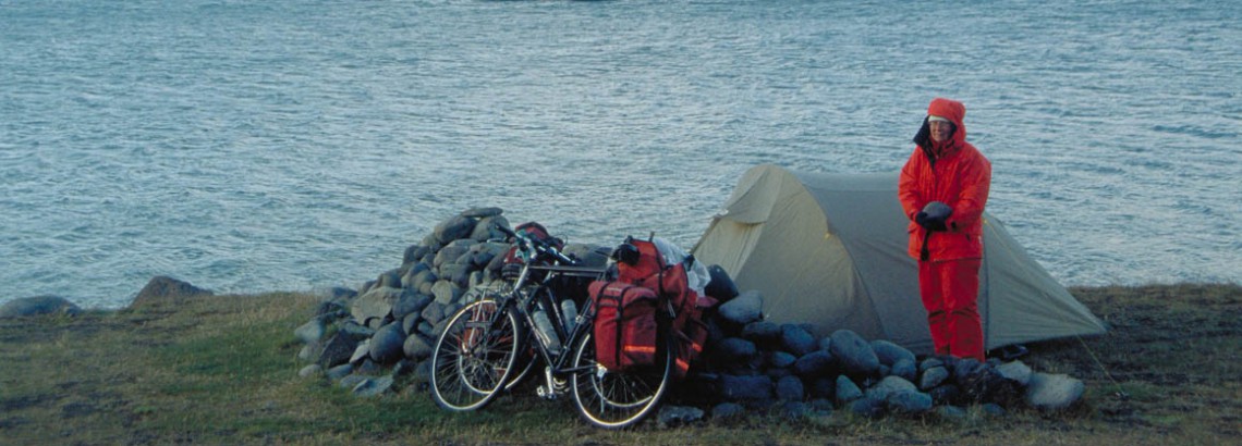
Keflavik town has all facilities. The campsite offers sheltered grassy tent sites, hot showers and cooking facilities. An amazing selection of groceries and fuels, left behind by other travellers, is available. Although travel and accommodation guides state that Keflavik campground closes around September 15th, the warden told us that the place stays open long after that. “As long as people come…”, he told us.
We decided to avoid busy Reykjavik and turned south on road nr. 43 to Grindavik, past the well known Blue Lagoon. 20 Km further is Grindavik (campsite, shop), where the pavement ends. A very rough gravel road with some steep sections (12% and 16%) follows the shoreline. Near the junction with road nr. 43 seasonal camping is available. A few kilometers of paved road bring you back on rough gravel. Most of the road is flat. In the small settlement of Strandarkirkja seasonal camping is possible behind the T-Bær restaurant. Grassy sites, hot showers and great cakes!
The Grindavik – Strandarkirkja road gives you an excellent introduction to Iceland. Lava fields, gravel roads, steep cliffs and the endless ocean!
Another 20 kilometers of gravel follow before you get to the paved Reykjavik – Þorlákshöfn road. We continued to Eyrarbakki (campground) and north to Selfoss. Selfoss is a big town with all services (campground with cooking facilities).
Selfoss – Gülfoss
We followed the ring road for 15 kilometres and turned north on highway nr. 30. The road is flat and traffic is much less than on the ring road. At Brautarholt seasonal camping is possible near the swimming pool. We passed the greenhouse village Laugaras (shop and 3 campsites!) and turned right again to Reykholt (good shop, camping) and further along road nr. 35 to tourist hotspot Geysir.
Already at the junction with highway nr. 37 (Geysir is still 5 kilometers away) you’ll be able to see Strokkurs steamy eruptions. Do all your shopping before Geysir as the shop doesn’t sell much more than postcards and candy bars. The camping area is pretty basic but the camping fee includes a free shower and a dip at the Hotel Geysirs swimming pool. Another 10 kilometres further is the impressive Gülfoss waterfall. The spot also marks the start of the Kjölur highland route.
The Kjölur Highland Route
The first 10 kilometers are flat. When Mount Blafell appears 12 kilometres of steep ascent follow. We had to push (walk) our bikes some parts. A huge pile of stones, left by passing travelers, marks the top of the pass. It’s a good spot to enjoy the views and to take a rest. A much smoother road descends to Hvitavatn Lake and the Hvita River. We camped near the bridge where flat grassy spots and plenty of water is available.
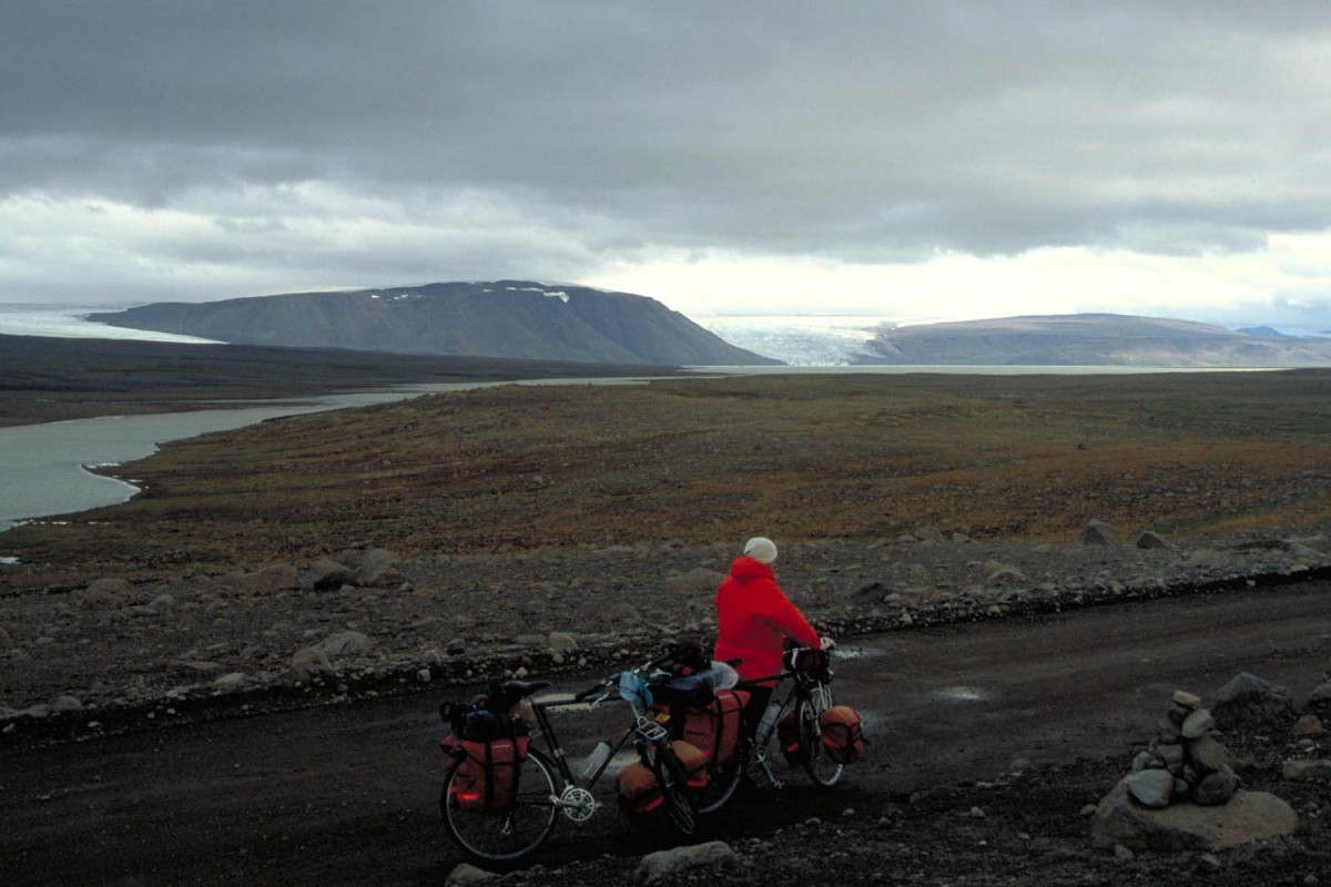
the Kjölur near Hvita Lake
Once on the highland plateau most of the climbing is over. The road is rough, stony and sometimes soft but steep climbs now lie behind you.
Another 10 km from the bridge is Abudir Hut. It’s just 200 m from the main road and a convenient overnight stop. Camping is permitted and there are even hot showers! Note that unlike the huts near the lake this hut is not shown on every map. Again 20 kilometres further is another hut; less than 2 kilometres from the road. The junction is signposted. Later you reach the highest point of the Kjölur at 672 metres above sea level.
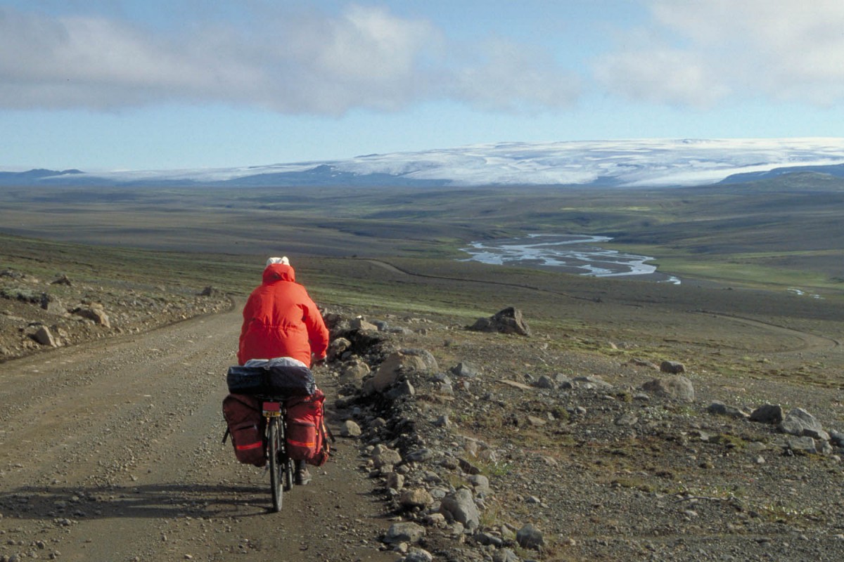
the Kjölur mountain road south of Hveravellir
Hveravellir – a good place to rest halfway
The road then makes a wide turn towards Hveravellir. The last 10 kilometres are very rough with lot’s of golf ball size gravel and soft sand. Hveravellir has a campsite and a mountain hut with a tiny shop (bread, canned veggies). It’s a lovely spot where you can rest and bath in a hot pool.
Back on the road north the first 5 kilometres of the road are still bumpy and rough but generally improve. 17 Km from Hveravellir is an orange coloured emergency hut. We had a look inside and read the guest book. Dozens of cyclists must have used this tiny cabin (4 berths and a table) to escape wet and windy weather.
Most of the kilometres that follow are gently downhill and surprisingly smooth. The landscape however is rather uninspiring. Most you’ll see is flat and grassy sheep country. Back into civilisation the road hits the ring road. Only a few kilometres to the east is a small campsite at a farm.
For 6 kilometres the ring road climbs steeply out the valley. Twenty easy and mostly downhill kilometres further is Varmahlid (campsite, supermarket, atm). We continued along the ring road; it crosses the fjord and follows a valley. This area, Öxnadalsheidi is remote and beautiful. The emergency hut, shown on some maps, no longer exists.
The valley widens at km 60 and passes a rest area with excellent facilities. Toilets and picnic tables and some fine spots to pitch a small tent. Officially camping is prohibited. 30 Km further is big town Akureyri.
Akureyri – Myvatn area
The ring road crosses the fjord and starts to climb (6 km) with lovely views down to the city of Akureyri. It’s downhill to Godafoss waterfall. Just before the falls is the Ljosavatn lake (an Edda hotel and camping nearby). Near the waterfall is a small campsite and a equally small shop.
The road crosses some hills and descends to the village of Laugar (seasonal camping and other accommodation, shop), climbs again to Masvatn Lake and finally descends to Myvatn. Cycling around the lake is pleasant with numerous stops to enjoy views and take pictures (as long as the famous midgets are not too obtrusive). The Krafla volcanic area makes an interesting destination for a day trip by bike…
From Reykjahlid we took a bus to Djupivogur on the east coast. Getting our bikes on the bus was no problem as there were only four other passengers.
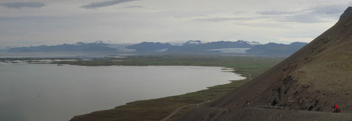
Djupivogur – Höfn – Skaftafell NP
the unpaved part of the ring road
The ring road closely follows the sea shore. There are no spectacular climbs to challenge although the road is by no means flat. There are some unpaved sections but these are smooth. And there are few facilities such as shops.
There is one very steep section just east of Höfn where the unpaved ring road descends 16% towards Höfn. A sign marking the top tells: “If you have not looked out over this fjord on a beautiful summer day and enjoyed the view, you haven’t seen Iceland…”
Höfn is 4 kilometres off the ring road and has several supermarkets and a campsite. Three kilometres further on the ring road is Nesjavellir. A small town with a gas station and a shop. We found the shop closed, but couldn’t find out wether it was closed seasonal or permanent.
steep section of the ring road, a 16% descent to Höfn
The road after Höfn is a rather boring affair: farmland, farmland, and farmland. It’s only after more than 40 km that things start to look more interesting. At km 54 is Vagnstadir, a YH with camping facilities. According to the official YH-brochure Vagnstadir closes on August 31st but we found all buildings open (and no one, not even the warden, around).
Jökulsarlon
Less than 30 km down the road is Jökulsarlon, the famous iceberg lake near a glacier. It’s a busy place where tour buses, campers and cars drive on and off all day.
Despite this, the ice berg studded lake looks stunning and one can easily spent a day just gazing at it. There is a small restaurant near the parking area but no other facilities. Keep your eyes open for Jökulsarlon’s curious seals.
Camping is allowed but not encouraged. Because of the strong wind (we couldn’t go further) we camped here for one night. Sheltered tent sites can be found at the western side of the bridge close to the lake. Get drinking water from the restaurant as the water from the lake was brackish (the sea is only a few hundred metres away).
Our next stop was Skaftafell National Park. At the junction with road nr. 988 is a petrol station with a small but well stocked shop. Before you enter the NP there are some farms that offer (sleeping bag)accommodation and camping.
The Skaftafell NP campsite is huge and during the peak season the limited numbers of showers and toilets must cause long queues. The shop sells a limited selection of groceries. By the beginning of September most items seemed to be sold out.
Skaftafell – Hella
Traveling west you’ll have to cross the sandur of some really big glaciers. This is the place where the 1996 Jökulhlaup raged.
The 1996 Jökulhlaup
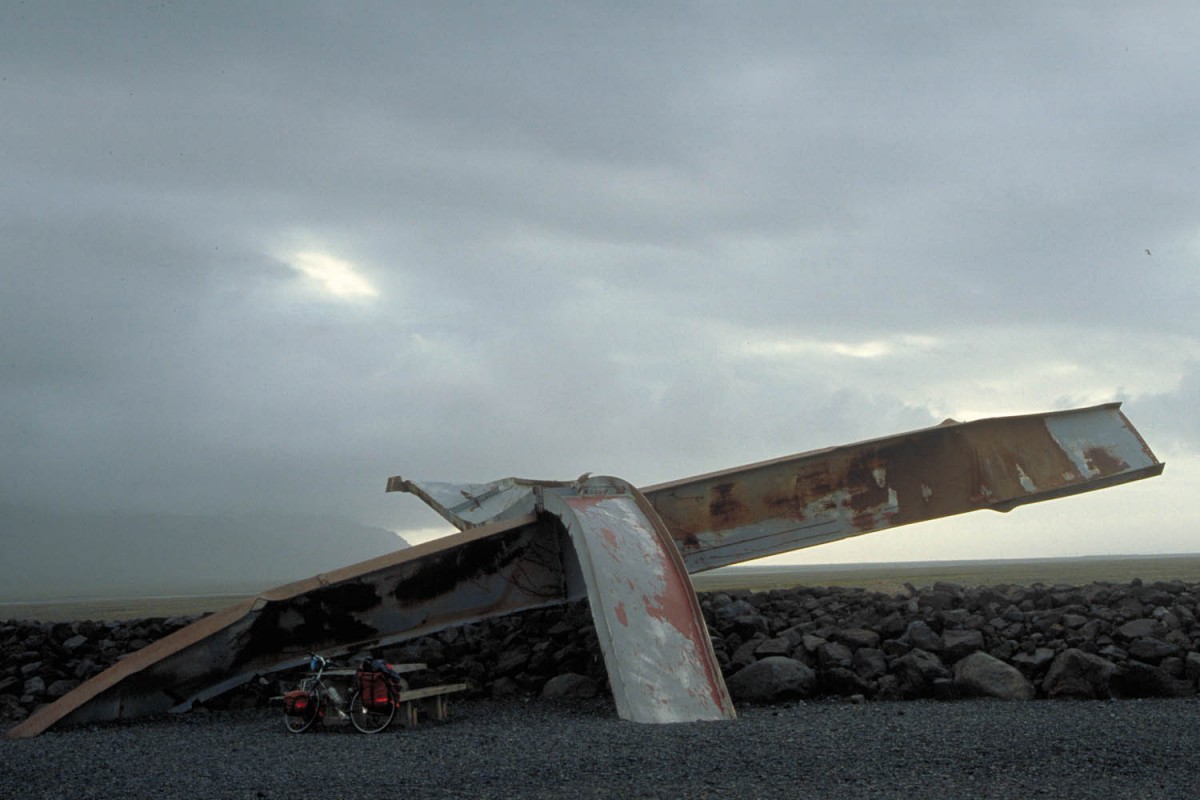
the remains of a bridge after a gigantic flood
On the 29th of september 1996 a volcano under the Vatnajökull icecap erupted. The 400 m thick icecap collapsed and gigantic floods (a ‘jökulhlaup’) wiped away much of the ring road on its way to the sea. Enormous multi-tonne blocks of iced burled towards the sea destroying several bridges. The remains of one of these bridges can be seen along the ring road.
We were lucky, a strong south easterly wind pushed us towards Kirkjubæjarklaustur. During high winds this road may be closed as sandstorms make travel impossible or too dangerous.
After 35 km high cliffs move into sight. Tenthousands years ago this was the shoreline. At Nupsstadur there is a lovely old little church to visit. All the way to Kirkjubæjarklaustur you’ll see waterfalls tumbling down the cliffs. Kirkjubæjarklaustur (supermarket) has two campsites. The one in town has excellent facilities (the best we’ve seen on this trip), including a washing machine, a dryer and wet weather- and cooking facilities.
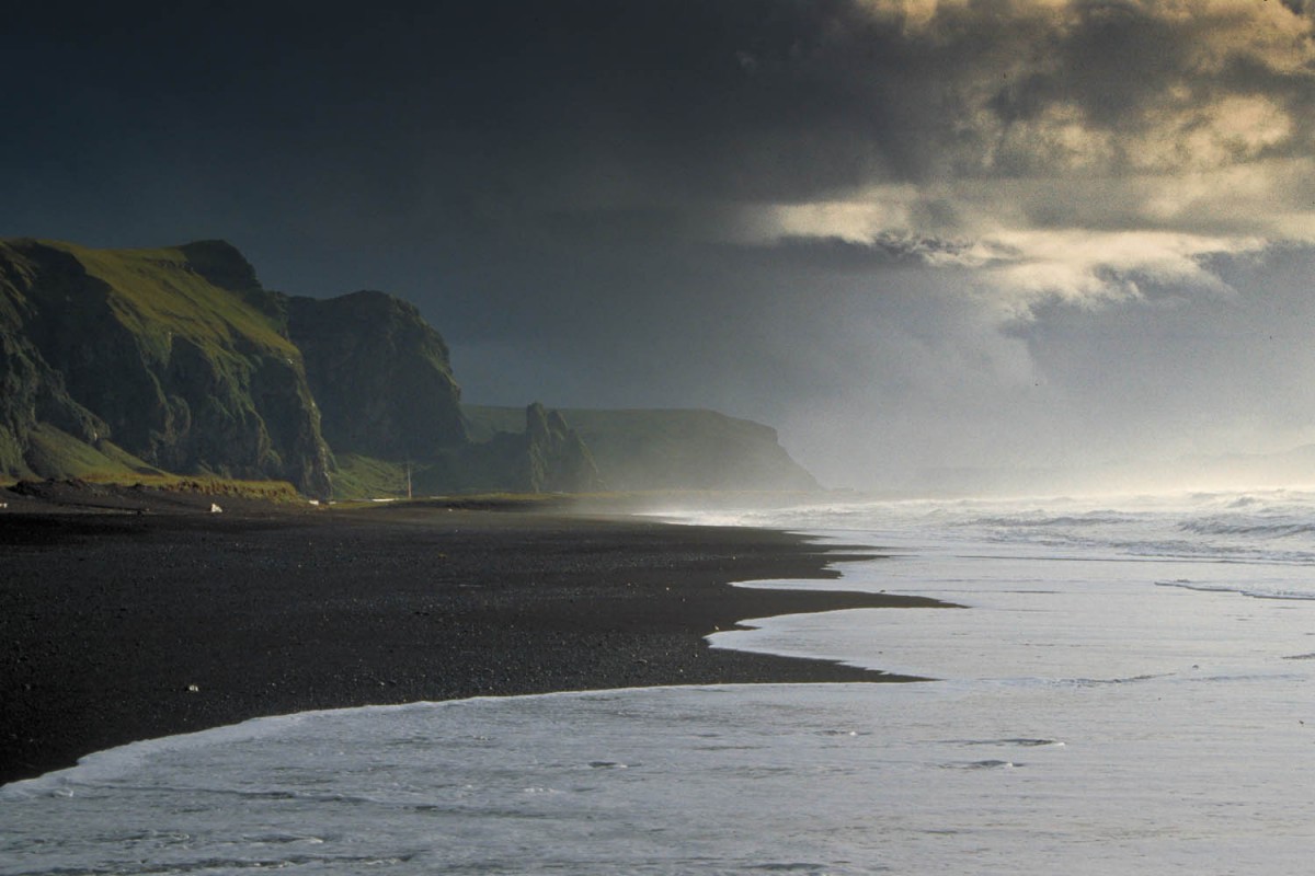
the beach at Vik
From Kirkjubæjarklaustur the ring road leads through vast lava fields and sandurs. On the road to Vik are three rest areas. The third offers excellent camping possibilities (water nearby, sheltered). Vik has a nice campsite (cooking facilities) and a supermarket that is only open on weekdays.
Push your bike up the steep 12% hill behind Vik and roll down at the other side. Not far away is Skogar with 2 museums, a hotel and basic camping near the Skogarfoss waterfall. Another 15 km further is a petrol station with a tiny mini-market. The rest of the road to Hvolsvollur (camping, supermarket) and Hella (year round camping, good supermarket) is flat and boring. Traffic increases significantly.
Hella – Þingvellir NP
North on highway nr. 30. the road is flat and traffic is less than on the ring road. At Brautarholt seasonal camping is possible near the swimming pool. We passed the greenhouse village Laugaras (shop at the petrol station and 3 campsites!) and turned left on road nr. 35 and north on road nr. 37 to Laugarvatn.
Laugarvatn is both a lake and a town. The area is famous for its geothermal activity. The campsite is at the northern side of town. Although it was closed we camped here. Toilets and showers were closed but water was still running from the taps.
A lovely gravel road cuts through the hills behind Laugarvatn to Þingvellir National Park. This road has some steep sections (16%) most of which are paved. It’s a nice short 16 km excursion into the highlands. The road finally descends to Þingvallavatn Lake. The park is worth is visit. The Visitors Centre is a postcard and candybar place, rather than a valuable source of information. All but one of the five campsites close around August 31st. The main campsite next to the Visitors Centre has free hot showers.
One of the parks main attractions, the Allmanagja fault, is easily accessible for cyclists. The path is wide and well paved.
Þingvellir – Reykjavik – Keflavik
Those wanting to travel to Reykjavik have two options. Taking main road nr. 38 for a long downhill all the way to Reykjavik’s suburb Mosfellsbær. Or going south along road nr. 360 for a more scenic but also longer ride. This option requires a number of short but steep (16%) climbs. Probably this road carries less traffic than road nr. 38.
We took road nr. 38 to take full benefit from a gale force tail wind that pushed us at high speeds towards the coast. Once we saw the skyline of Mosfellsbær traffic increased dramatically. Just follow highway nr. 1 to get to Reykjavik. The ring road transforms rapidly into a multi-lane highway full of speeding cars. Cycling becomes unpleasant. See the the ‘In and out of Reykjavik’ section below to get some ideas about low-traffic routes into town.
In and out of Reykjavik
A dense network of multi lane highways and clover leafs is laid out around the city. Cycling is officially allowed on these roads but at most times very unpleasant. Why cope with thousands of speeding cars when there are some interesting alternatives? To find these you’ll need a map of Reykjavik and it’s suburbs. Get one for free at the Tourist Information. Some of these maps even show Reykjavik’s limited network of bike lanes. For those who cannot get a map we’ve written down some scenic 😉 routes in and out of town.
Entering Reykjavik from the north starting at Mosfellsbær just stay at highway nr. 1. There is no real alternative yet. Bike past a clover leaf (the turn off to Borgir, Grafarholt and other suburbs) and keep your eyes open for a sign pointing towards a bridle trail. This small gravel path leads you away from the big highway. It ends on a less busy road; this is Storhöfdi. You bike through a industrial area until you reach the T-junction with Breidhöfdi. Turn left and turn right again at Bildshöfdi. Follow this road until you get to a roundabout. Straight on is the beginning of a paved bike lane. This lane finally crosses Sæbraut (traffic lights). At the other side keep left and you’ll reach a bike path that follows Miklabraut almost all the way to the centre. Those traveling to the campsite can follow a bike lane along Sudurlandsbraut. This lane passes through the park with the Reykjavik Zoo, the botanical garden and the campsite.
Reykjavik – Keflavik
A nice bike path starts at the junction of Hringbraut, Miklabraut and Snorrabraut. It winds through the park with Perlan and the city’s cemetery and finally ends on a small street (Sæbolsbraut) that ends on Karsnesbraut. Turn left and continue into Nybylavegur. Turn right on Brattabrekka and bike left into Digranesvegur. Turn right on Dalvegur and left again on Fifuhvammvegur. After just a short distance you’ll hit the junction with Reykjanesbraut. This is highway nr. 41 that will lead you all the way to Keflavik. A few kilometres south is the city of Hafnarfjördur.
Once you get to Hafnarfjördur there is no other option than to follow road nr. 41 to Keflavik. The road is busy but has a wide (> 1 meter) and paved shoulder to ride on. Road nr. 41 is mostly flat with some minor hills. In September 2003 road workers were busy constructing 2 extra lanes. It looks like this road will be transformed into a Iceland’s first real highway in the very near future.
