All information on these pages is based in our personal experiences while cycling through South Africa in September 2002. This page describes the day to day route we followed.
We flew to Durban cycled along the south coast and crossed Lesotho. We traveled through mountainous Eastern Lesotho to Thaba Tseka, Katse and then to Leribe and Butha Buthe were we left the country. Back in South Africa we continued through Golden Gate and Royal Natal National Parks via Howick and Pietermaritzburg back to Durban.
Overview of our route and map
The purpose of this cycling trip was to see something of South Africa. We were attracted by the Drakensberg mountains (the area is a World Heritage Site) and we also wanted to visit the kingdom of Lesotho. The complete route, as described below, leads through mountainous country and includes some extreme climbs (such as the famous Sani Pass).
Durban – Park Rynie
Durban’s airport is located at the southern side of the city. Thus the most convenient route away from the city is due south along the coast.
Want to store bike boxes or other stuff? The Airport had a Left Luggage facility.
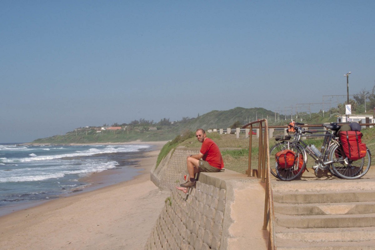
enjoying sun and sea along the ocean road south of Durban
From the airport terminal cross the freeway (the fly over is1 at your right) and turn left onto the R102. The R102 passes through an industrial area before reaching the ocean. The ocean road is also signposted as ‘Kingsway’. Once you have left the industry behind you enter the town of Amanzintoti. There are several B&B’s all along the coast. This road is not very busy and most cars drive slowly. The road all along the coast is hilly but never steep.
Park Rynie – Himeville
All along this part the road is wide, has a good shoulder and carries few traffic but it is a long way up. You’ll pass through a varied landscape of endless sugarcane fields and huge forests with gum trees.
The first 5 km are easy but the next 20 km are really uphill. At Breamar there is a shop for basic supplies. There are numerous Zulu-villages along the road; most of them will have a very small shop. The next ‘larger’ town is Highflats. There are shops but no place to stay. We slept in the courtroom at the local police station. Another 24 km further (of which 6 are downhill) is Ixopo (atm, shops, hotel). The road continues along a ridge with views of hundreds of rondavels in the valleys below.
Just before Donnybrook (hotel, shop, atm) is a nice descent. On the road to Underberg you’ll pass a turn-off to two missions that offer accommodation. Just outside Donnybrook is Mission Kevelaer and 20 km further is Mission Reichenau.
The road passes through an agriculture area and there are no steep climbs any more. Underberg has several supermarkets, atm’s, B&B’s but no campground. The next campground is at nearby Himeville. The 5 kilometres to the village of Himeville are one of the few flat ones we cycled on this trip. Just outside Himeville is the turnoff to Sani Pass.
Cycling to the top of Sani Pass
Along this road (from here 30 unpaved km’s lead to the top at 2864 meter) are three places to overnight. The first is Sani Lodge (backpacker-style accommodation, offers meals as well), the second the very luxurious three-star Sani Hotel and another 6 km further the Mkomazana Lodge (the budget accommodation here in a large shed looks rather uninviting).
16 km beyond Sani Lodge is the Southafrican border post. The top of Sani Pass is another 8 km up the road and 4×4 only. We could cycle all the way to the Southafrican border post. Tourist Information says it takes 3 hours to walk the remaining 8 km; with a heavy loaded bicycle you should add an hour or so.
way down is the South African border post
These last 8 km we really had to push our bikes up. The road was either to steep or to rough or both. The last section with the hairpins is very steep and we were lucky to get some push-help from two Basotho men.
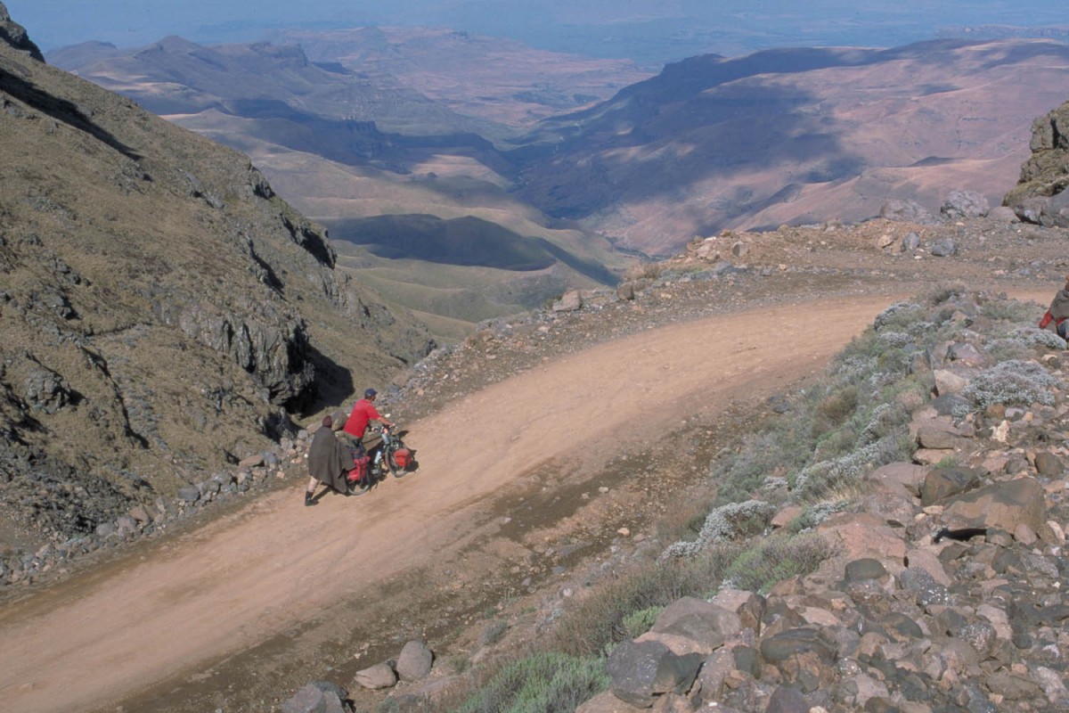
we were lucky to get some push-help from two Basotho men
It was not until 1948 that this route was attempted by a vehicle. The road twists steeply in a series of spectacular loops and U-bends to the Lesotho border post. Sani Pass is the highest mountain road in Southern Africa. At the top is Sani Top Chalet providing accommodation, meals and the highest pub in Africa.
There is a regular stream of cars going up (and down). Many day-trippers visit Sani Pass. Hitchhiking should be possible. Warning: in and after wet weather the Sani Pass road becomes very muddy and slippery.
Do not worry about checkpoint times at the Lesotho side. We arrived at 15.30 hour and found the office already closed. There is no gate that closes, so continue to Sani Top Chalet and return to the office next morning.
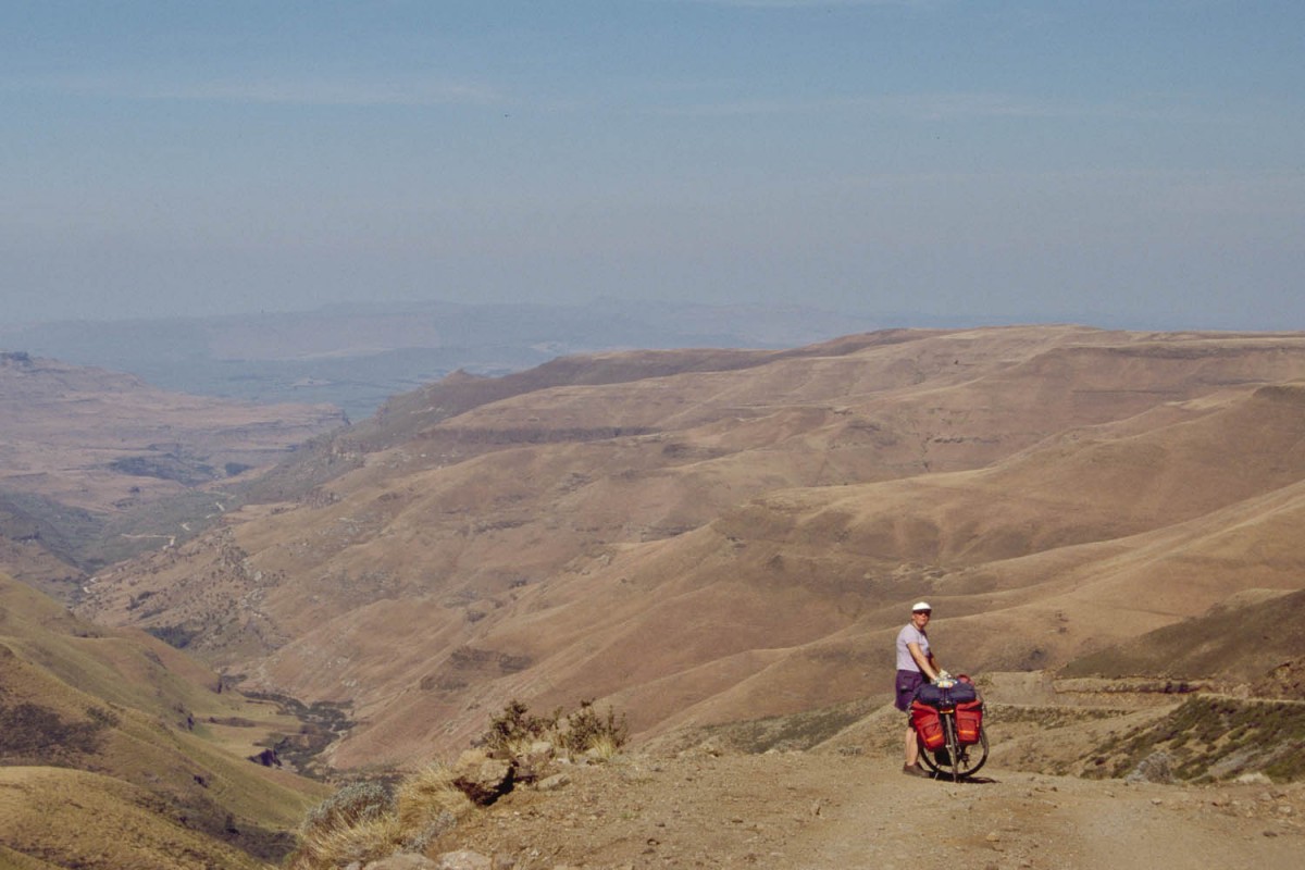
Sani Pass – Mulomong (Lesotho)
The first 7 km you’ll cross the Sani Flats. Probably the last flat country you’ll see in Lesotho. The road then climbs steeply another 3-4 km to the first summit of Black Mt, 2 km further uphill is the actual pass (3240 m).
On a clear day you will enjoy splendid views of the 3482 m high Thabana Ntlenyana; the highest point south of Mount Kilimanjaro.
A rocky, bumpy and narrow road descends steeply for 6 km. Down in the valley there are 3 small rivers to cross. We had to take off our shoes and walk across all three of them. Just beyond the last ford is civilisation. Small villages with no facilities. This road is a fair weather road so it can become impassable in and after wet or snowy conditions. Those who want to go to Mulomong Guesthouse and Thaba Tseka are warned. There is river to cross! In Lesotho this means that you’ll ride into a deep and narrow valley hanging on to your brakes. Cross a low bridge and then at the other side climb out as steeply as you came down.
It’s uphill all the way to Rafolatsane village where Mulomong Guesthouse (signposted with small sign) offers basic but good accommodation.
There is a shorter road to Rafolatsane that we did not take. It branches off miles before the bridge and joins the Thaba Tseka road near Rafolatsane. We have no information on the condition of this road. It’s on some maps and there is a sign pointing to Thaba Tseka..
Mulomong – Thaba Tseka
This is remote and mountainous country. We did hitchhike most of this stretch. We discovered that these hills and mountains where just a bit to steep to ride with our heavy loaded touring bikes. There is not much traffic on this road that goes all the way. Most taxis, busses and other public transport will only stay at one side of a high pass.
After another steep climb, a tortuous descent from Menoaneng Pass (3250 m) follows down to the the small village of Taung (we camped here next to the rondavel of the village chief). From here the road descends steeply for 4 km to the Senqu River.
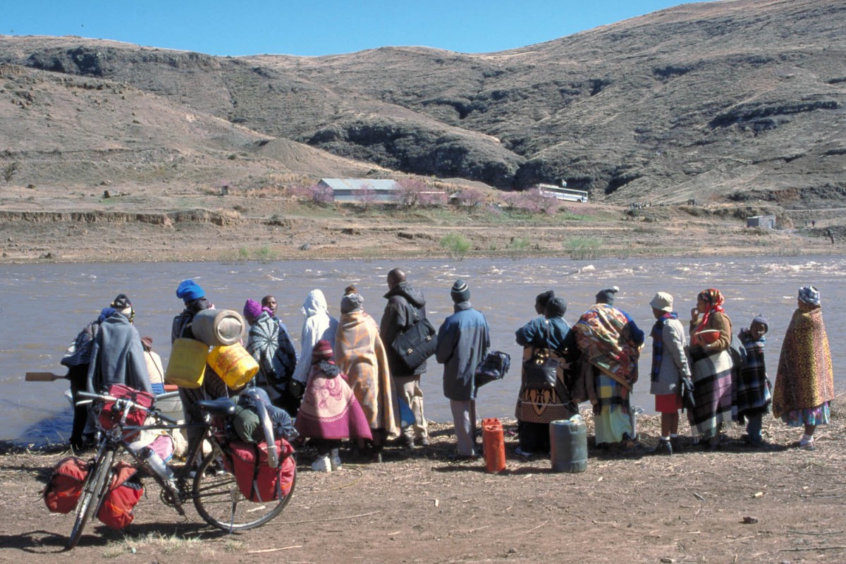
There is a low-level causeway across but whenever the Katse dam further north is opened to let out water (mostly after heavy rainfall) the bridge is easily flooded and all traffic stops here. For pedestrians and cyclists there is however an solution. The government of Lesotho provides a free ferry-service at these days. A small rowing boat leaves from a spot a few hundred meters upstream from the bridge. It took us 3 hrs to get across; there were many other people waiting.
From the river the road climbs seemingly without end. The next place with some facilities is Thaba Tseka. It now has a good hotel; ask for the Mountain Star Hotel as it was not (yet) signposted in September 2002.
Thaba Tseka – Leribe
The road from Thaba Tseka to Katse is ‘flat’ compared to the roller-coaster ride through previous sections. The mountains here are further apart; the landscape looks wide and more open.
At Katse the pavement starts. This road is in an excellent condition. On the first section to Lejone there are 2 passes (2510m and 2650 m). From Lejone (accommodation, shops) the road follows the dam (lake) and then climbs very steep for approximate 15 km to the first summit. The real pass (Mafikia Lisiu at 3090 m) is still a few more km uphill. From the viewpoint you’ll have sweeping vistas of the many hairpins at the other side. The first 10 km downhill are very very steep. From the top of this pass Leribe with all facilities is only 55 km away. Most of these are downhill!
Leribe – Caledonspoort (South Africa)
A good paved road leads to nearby Butha Buthe (30 km). The Southafrican border is 10 km north of Butha Buthe at Caledonspoort.
You may call this part of Lesotho hilly or even mountainous, but it’s nowhere as steep and challenging as the highlands to the east. Still the Lesotho lowland is 1600 m above sea level.
Caledonspoort – Royal Natal National Park
On the border is the Camelroc Guest farm (accommodation and camping). 10 km north of the border is the tiny town of Fouriesburg. It has a hotel, B&B’s and some shops.
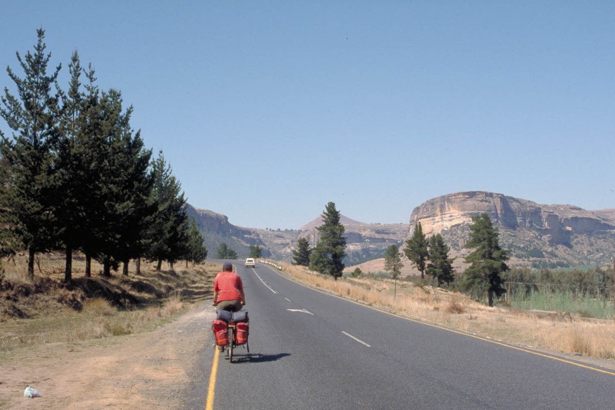
The touristy town of Clarens is 35 km from Fouriesburg. An undulating road passes through mainly agricultural area with nice views of the mountains to the west. Clarens has numerous shops most of them selling art and handicraft products. There are several B&B’s.
The Golden Gate Highland National Park is nearby. There is accommodation in cabins and a caravan park. The park has a small shop that sells cold drinks and some groceries.
The Kiava Lodge just before the park entrance also offers camping.
The road passes straight through the National Park and adjoining Qwa Qwa National Park. Outside the parks you’ll pass through endless agricultural areas. The town of Putjadithjaba is on this road. It’s centre is located far off the main road. On the main road there is however a Hotel & Agricultural School with sign telling that they offer accommodation. This might be an interesting place to stay.
The scenery here is not very interesting. The road undulates through pastures all the way to the Sterkfontein dam turn-off.
The R74 has a very wide shoulder and follows the Sterkfonteindam along its full length. There is accommodation at the dam (chalets and camping). The caravan park is 3 km from the entrance gate. This place can be completely deserted at weekdays (as we experienced) but overcrowded at weekends and public holidays (as we were told).
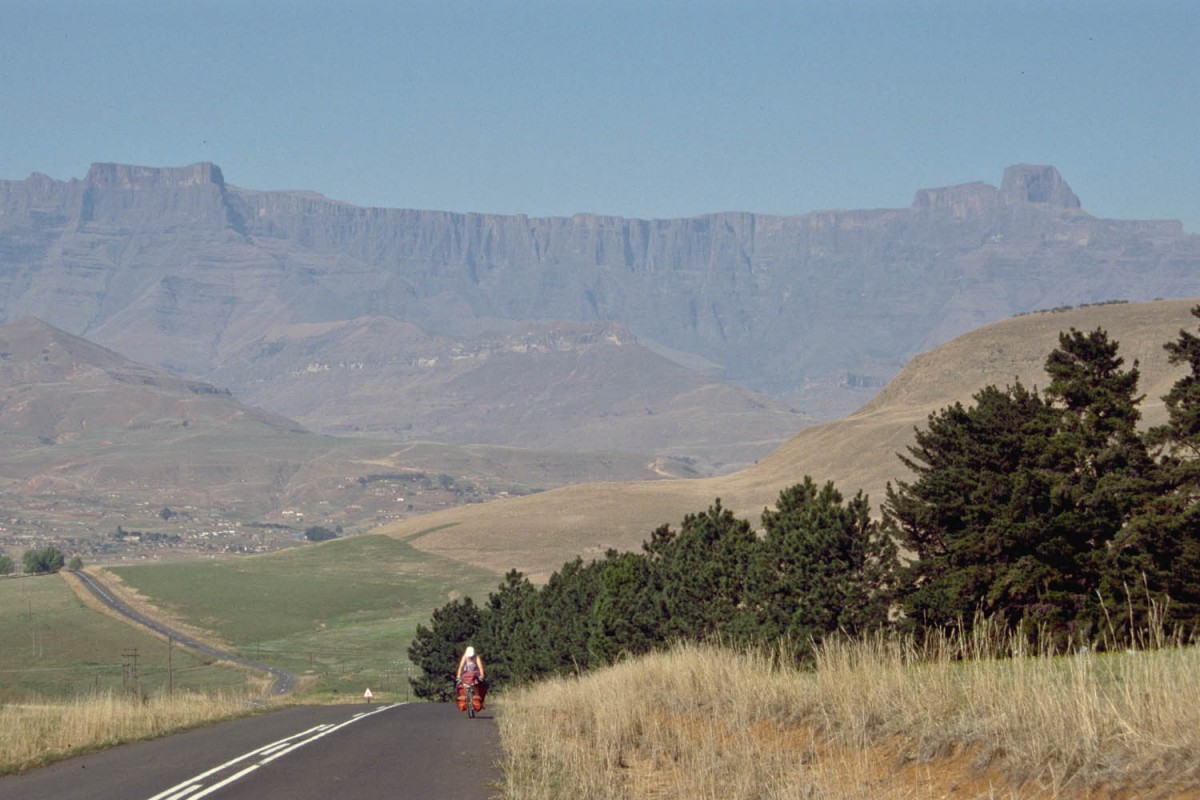
20 km further along the dam is Oliviershoekpas at 1730 m. Actually it is the top of the pass when you come from this direction. In three sections (the steepest is 10%) you descend to the Royal Natal National Park junction. The park is 20 km down the road. The lowest point of the park is at 1450 m; the highest (the top of the Amphitheatre) at 3000 m.
A more scenic road to the park entrance, though a bit more challenging, branches off near the Tower of Pizzas B&B and restaurant. Turn right here to the Mount Au Sources Hotel and the Rugged Glen Caravan Park. This road ends very close to the Nation Park entrance.
The Visitor Center has a small shop with basic supplies such as meat, bread, canned veggies, beer etc.
Royal Natal – Pietermaritzburg
The road to Bergville hasn’t a lot to offer. Yes, there can be some good views of the distant Drakensberg-mountains (weather permitting) but the rest is just cattle-country. Farm-stalls sell souvenirs, farm produce and cold drinks.
Bergville has shops and accommodation. Twenty km further is the small town of Winterton (shops and accommodation). Those who want to camp: 15 km north of Winterton is the Spioenkop Dam and Nature Reserve.
Rolling hills continue to Estcourt (all services). Just outside Estcourt the road climbs steeply to the Griffin’s Hill, continues along a plateau and descends again steeply towards Mooi River. Mooi River has a all services and a caravan park.
Climb out of Mooi River to Rosetta and Nottingham Road. You’re on the touristy Midlands Meander here. In this hilly forested area, that looks very European, are many lodges, B&B’s, craft shops, galleries etc. The road can be very busy on weekends with slow moving tourist traffic. From Nottingham Road it’s downhill all the way to Howick. From Happy Hill the road descends steep to Howick. Watch for the Nelson Mandela monument along this road. It marks the spot where he was arrested to be jailed for 28 years on Robben island. Howick is at an elevation of 1050 m.
Cyclists who want to travel to Pietermaritzburg should follow the R103, the Old Howick Road. This road crosses the freeway several times and takes you to the wealthy village of Hilton. From here it’s downhill again. Ten km of busy, narrow and winding road bring you to the western end of Commercial Road, one of the main streets of down-town Pietermaritzburg.
Pietermarizburg – Durban
It may be possible to continue on secondary roads to Durban. We choose to avoid entering busy Durban at all, and take an alternative road that leads to the southern edge of this big city. This would also bring us back close to our starting point: Durban International Airport.
To find your way out of Pietermaritzburg follow:
1. West road (it becomes College Road)
2. Turn right into Alexandra Road
3. Turn left into Ritchie Road
Once on Ritchie Road keep going for about 20 km. At the town of Umlaas Road signs will direct you to the R603 to Kingsburgh through Umbumbulu. You’ll pass some hilly area. There is a small shop at Eston. The extensive village of Umbumbulu. (we saw hundreds of school kids along the road, so it must be large) marks the start of the final descent to the Indian Ocean. When you hit the ocean road you are only 30 km south of Durban International Airport.
