All information on these pages is based in our personal experiences while cycling through Alaska in August and September 2000. For those with limited time to cycle in Alaska there is a separate page about cycling in Denali National Park.
Maps; getting around
There are few roads in Alaska so for most cyclists a basic map will be sufficient. Free maps are available from gas stations, tourist-offices, at RV-parks and motels.
On the WWW good maps are available from www.expedia.com. Such as this online map of Alaska that permits you to zoom in even on street level in small towns like Nenana or Cantwell.
A basic map, including the distances between all towns, of the part of Alaska we visited can be found at our route page
But for those who want a really detailed collection of maps covering the whole state there is the Alaska Atlas & Gazetteer. This large size paperback atlas contains more than 100 topographical maps showing just about every landmark. At 20 US$ very good value. We bought one in a Valdez supermarket, removed the pages we were going to use on this trip and used the remaining 80 pages as fire starters for our nightly campfire!
For those cycling around Anchorage and Fairbanks the Tourist information offices have maps showing the bike-lane networks in both cities.
Signposting along all the roads we used is good; all distances are measured in miles ( 1 mile is 1.6 kilometers) .
Books
For general travel info we used the well-known Lonely Planet travel guide.
Links on the WWW
Sites for bikers
- 26 FAQ's about cycling in British Columbia and Alaska by Bob Broughton. One of the questions is: Is it possible for a cyclist to travel faster than a pursuing bear!
- Travelogue by Dennis and Marijcke from the
Netherlands who did a similar trip as we did but on a
tandem bike in September 1999. In Dutch with various
photographs.

- For a good selection of other Alaskan bike pages start at Raph de Rooij's Travel to the Horizon site.
- the Arctic Bicycle Club
General info about Alaska
- The Alaska Public Lands Information Centers; for outdoor information and trip planning.
- The Alaska Bureau of Land Management; a useful source of maps and background information.
- The Alaska State Parks website.
- The National Weather Service Alaska Region or check out the current weather in Alaksa with the webcam in downtown Anchorage.
Roads and Traffic
All the roads we traveled are in a good condition and traffic is light. The George Parks Highway (Anchorage to Faitbanks) carries more traffic (including trucks) than the Richardson Highway (Valdez to Fairbanks).
Most roads have a shoulder (small strip on both sides separated by a line from the main lane) that can be used as a bicycle-lane. Traffic is relaxed. Cycling into and through the cities of Anchorage and Fairbanks is easy.
Traffic is on the right hand side of the road.
Your bicycle
Outside Anchorage and Fairbanks not much is available to repair a broken bike. See our multi-language bicycle vocabulary if English is not your native language and you have to communicate with Alaskan bike shop staff.
Food and drinks
During this trip we camped all the time (with two exceptions) and bought and prepared our own meals. For the self-catering every town has a supermarket or at least a small general store. At Anchorage, Valdez, Delta Junction and Fairbanks there were large well-stocked supermarkets. See for the details about shops and supplies the specific sections of our tour report. It is not necessary to carry more than 2-3 days of supplies.
On the Richardson Highway...
We cooked our own food on a gas (car fuel) stove. Special white gas for camping stoves is available at many places along the road but mostly comes in huge one gallon (4.5 liters) containers. One liter cans were only sold in outdoor shops in Anchorage and Fairbanks.
See for the details about shops and supplies the specific sections of our tour report It's safe to drink water from the tap. Do not drink water from rivers or lakes without proper purification.
Climate
in Anchorage
Current weather
in Fairbanks:
 We
visited this Alaska from August 18 to September the 19th.
Weather varied from day to day. We had some warm and sunny
days at around 20 degrees Celsius and on two occasions had
serious snowfall on our route. Throughout the day
temperatures were mostly hovering around 5-10 degrees
Celsius; nightly temperatures were often below zero.
We
visited this Alaska from August 18 to September the 19th.
Weather varied from day to day. We had some warm and sunny
days at around 20 degrees Celsius and on two occasions had
serious snowfall on our route. Throughout the day
temperatures were mostly hovering around 5-10 degrees
Celsius; nightly temperatures were often below zero.
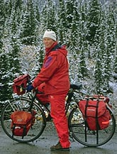
Be prepared for cold (freezing) nights and bring good rain gear including warm (waterproof) gloves and waterproof shoe-covers.
The period we did this trip was definitively off-season. And that was exactly the reason why we came in fall. Campgrounds are not crowded (sometimes even deserted), tourist traffic is far less and getting into Denali NP is no problem.
From September on there are chances you can see the Northern Light. Not only the sun sets earlier but auroras seem to be more common in spring and fall. The drawback is that you may have to get out of your warm bed or sleeping bag in the middle of the night or very early in the morning. We spotted a small aurora once.
Bears & bikers
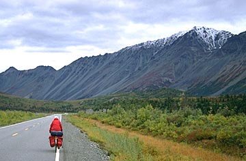
Georg Parks highway
 Before you set off on
your Alaskan bike tour it's a good idea to read something
about these potentially dangerous animals.
Before you set off on
your Alaskan bike tour it's a good idea to read something
about these potentially dangerous animals.
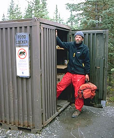
Basically all you'll have to do is to store your food and other smelling items such as soap in a safe place. Some campgrounds supply lockers for this purpose. Most campgrounds however do not have a safe storage facility; they assume that you arrive in a car. So in most places we solved this problem by storing our food etc. in one of the toilets. This worked fine all the time.
What to do when you encounter a bear depends on the bear (black or grizzly). Brochures concerning this subject are available from Visitors Centers in the National Parks.
Denali NP has issued a separate leaflet with advice for cyclists in the park. More about this leaflet on our separate Denali page.
Where to stay
Hotels and hostels
On this trip we only used a few times non-camping accommodation. At Anchorage upon arrival and departure and at Delta Junction and Fairbanks to escape the cold and wet weather outside. Motelling in Alaska is not cheap. A double motel room started around 60 US$, a good middle class room did cost around 90 US$.
Camping
To fully enjoy the superb scenery of Alaska and it's National Parks, camping is a must. Campgrounds are within daily reach with a little bit of planning, along the route we followed. Before you set off from Anchorage head straight for the Bureau of Land Management and get the good value 'Public Lands campgrounds' map for just 0.25 US$!
Most state campgrounds are rather basic: a hand pumped water well, picnic tables and pit toilets. Sometimes bear-proof food lockers for cyclists and hikers are available. We found them only at Williwaw campground (Portage Glacier)at Byers Lake and inside Denali NP.
Be aware of the fact that many campgrounds start to close down after Labour Day.
Other ways of getting around
Of course cycling is the best way to get around, but the state of Alaska covers such a large area you may want to consider an alternative:
Ferry
The Alaska Marine Highway ferries run along Alaska's long coastline. We took the ferry from Whittier to Valdez. A memorable trip along glaciers, icebergs and other spectacular scenery. You pay extra to take your bicycle, reservations do not seem to be necessary.
Bus
There are many bus services available throughout Alaska. Some of them will take your bike (with advance notice and / or an extra fee).
- Alaska Direct Bus line Homer Stage Lines (Anchorage - Homer) Bicycles cost 25 US$ with advance notice
- Parks Highway Express (Anchorage - Denali NP)
- Seward Bus Line (Anchorage - Seward )
Train
Alaska Railroads operates three services. From May to September the daily Denali Star runs between Anchorage and Fairbanks. Baggage service is available. The trip to Denali takes about 7 hours. The 'Coastal Classic' train runs from Anchorage to Seward and also has a luggage car. The Glacier Discovery from Anchorage to Whittier connects to the ferry departures. This train doesn't have a luggage service and therefore takes no bicycles.
Questions?
If you still have some questions left do not hesitate to send us an e-mail. Frequently Asked Questions and answers about cycling in general can be found at the FAQ pages.
![]()